ATP Quick Links
Interested in Alaska?
Seeking a Job?
Signed a Contract?
Contact & Support


This page provides some key information about
Alaska for those who are considering moving here to teach or
work as school administrators.
According to the Institute of Social and
Economic Research, only about 30% of teachers in Alaska were
actually educated here, so you will be among friends. The
other 70% of us moved up at one point or other. We really do
want you to know what to expect, and choose a location and
district that will be a good fit for you and your lifestyle.
Many teachers who have worked in overseas
schools or served in the Peace Corps compare living and
working in rural and remote parts of Alaska more to working
overseas than elsewhere in the United States. This is
because the rural parts of the state frequently require
newcomers to adapt to both a different culture and a
completely different way of day-to-day life.
It is not uncommon for first time visitors to
come up for a Job Fair or even accept a teaching or
principal job without fully appreciating the special setting
that exists in Alaska. That is why the state requires
teachers to take mandatory Alaska
Studies and Multicultural
courses during your initial teacher certification period.
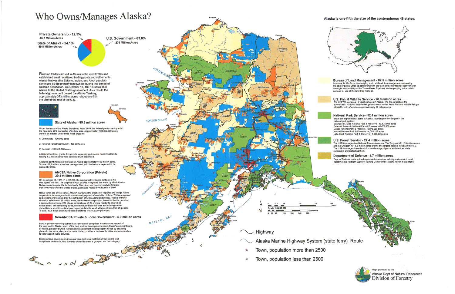
You will learn about the 1971 Alaska Native Claims
Settlement Act (ANCSA),
and learn how land ownership and other rights have changed
over time for indigenous people in the state. It is this
act, by the way, that lead to the Molly
Hootch
court case, and the rise of K-12 education
funded by the state in each village.
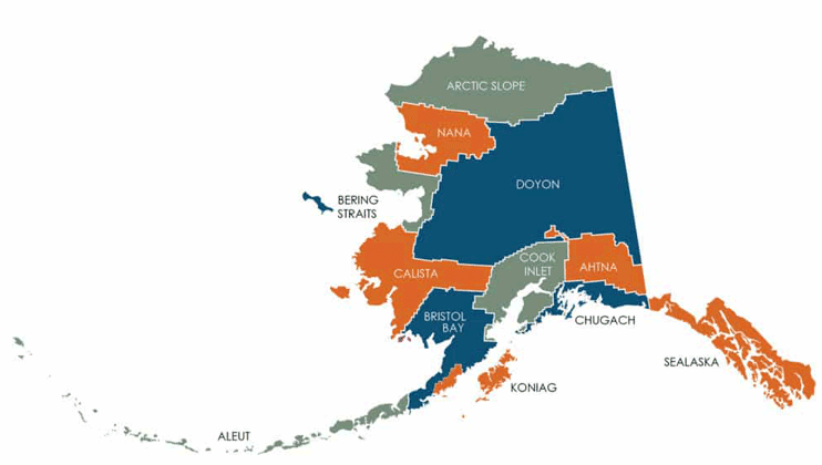
Here is a look at the twelve
tribal
corporations formed under ANCSA, and their
boundaries. Click on the map to go to the ANCSA site and
learn more about this topic.
We can't cover this topic well in a limited
space, but you should educate yourself as part of your job
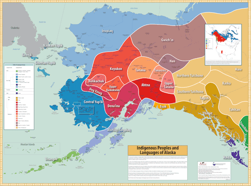
search. This map links to resources about Alaska's
indigenous peoples and language groups on the
educator-created Alaskool
site for teachers.
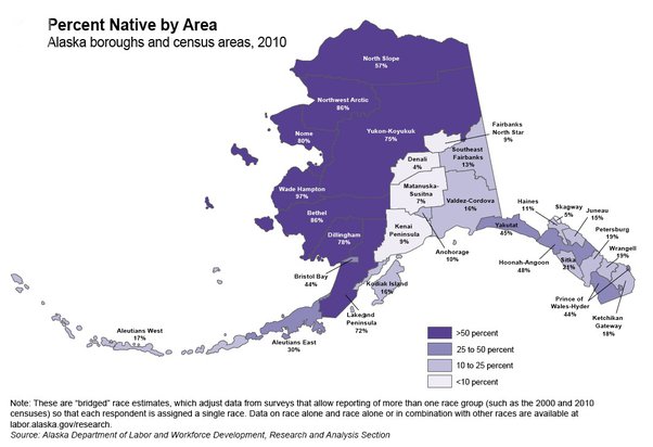
Although Alaska Natives make up a significant
portion of many communities throughout the state, here is a
distribution map using 2010 census data that shows the areas
with the highest concentrations of
indigenous residents.


Alaska is actually designated a "frontier area", and certainly it is the last frontier for educators in North America. Only some remote parts of Canada can compare in terms of maintaining schools in areas with frontier characteristics. Australia, too, has some isolated regions with small schools.
According to the Rural Policy
Research Institute, the majority of Alaska can only
fit into the category of a frontier. Frontier areas make
"rural" look pretty crowded. ;-)
The U.S. Census Bureau defines "Frontier"
areas as "less that 6 people per square mile". Alaska
averages roughly one person per square mile, or 1/6 of
"rural". Some sources using census data just put the average as
even "under one per square mile".
| Frontier Areas in the United States | How Does Alaska Compare? |
 |
Frontier
Area? Less than 6 people per square mile 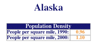 |
| Source: U.S. Census Bureau | |
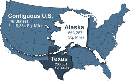
The scale of Alaska is misleading on most maps. This overlay shows how Alaska compares to the size of the Lower 48. If you teach on the island of Atka, in the western Aleutians, then you are as far from the capital of Juneau as Los Angeles, California is from Atlanta, Georgia. Alaska still has two time zones, and it used to have four. It is over 2,000 miles from east to west, and has 656,424 square miles.
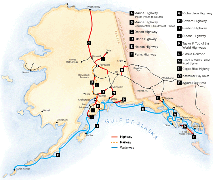
You will need to learn some new vocabulary terms in order
to make sense of Alaska as a potential new home. This
map shows the only highways, and the ferry system routes.
Alaska has developed some pretty specific slang
words and useful phrases
that you really will hear everywhere.
More importantly for those seeking jobs are
the designations that all communities typically fall under.
These are both widely used, and very important to
understand.
Key Term: "On the Road
System"
This means you can drive to that community from, say, Oklahoma, if you have time, gasoline and determination. Most roads in Alaska are two lane, and not necessarily paved in any recognizable fashion. Tar and chip isn't "paved" unless you've lived in the Bush. The Alaska Highway comes up through Canada, and connects us to the Lower 48.
The main highway system connecting Alaska to the Lower 48 is the Alcan Highway which comes into Alaska at Tok, near the Canadian border. The Alcan meets the Richardson highway which runs up to Fairbanks in the north, or the Glenn Highway which runs west to Anchorage. The Parks Highway connects Anchorage and Fairbanks. The Sterling Highway heads south from Anchorage to the Kenai Peninsula.
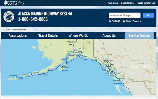
Most Bush residents consider coastal communities on the "Road System" if the Alaska Marine Highway System ferries serve that village on a regular schedule, such as most of those in Southeast Alaska.
Examples of school districts "on the road" would be Anchorage, Kenai Borough Peninsula, Mat-Su, Fairbanks, and Denali Borough. Juneau is connected by ferry to Washington state, as are most of the smaller towns and villages in Southeast.
Key Term: "In the Bush"
Well, everything else is pretty much in the Bush.
The vast majority of the state's communities are in rural or remote Alaska, also know as "the Bush". To get to the Bush, you have to fly or take a boat. Although some regional hub communities have a local system of roads, with the occasional car or truck, they are not connected to the rest of the roads in the state, or North America, for that matter.
Some of these, like Nome, really allow you to drive quite a ways – hours in fact – but, you still need to either fly your car there by air cargo, or send it by barge. Other example hubs with limited road systems – don't expect pavement – would be Dillingham, McGrath, Barrow, and Kotzebue.
Most villages, though, are fly-in only.
Typically, this transportation is via a small plane. We are
talking about somewhere between perhaps 10 other people, and
nobody but you and the pilot. On the upside, you won't have
to take your shoes off at the airport and you can keep your
beverages with you when you board. You will sometimes fly on
a twin turbo prop from Anchorage to a hub community, and
then transfer to a smaller, single engine plane. Landings
are on a dirt strip, sometimes using skis in the winter,
setting down on an "ice runway" smoothed out of the frozen
sea.
Here is an example of a sea ice runway takeoff
in a twin turboprop on a beautiful spring day near the
Russian border.
Bush village travel becomes quite routine for
most rural Alaska teachers. Schools fly students in aircraft
like this for basketball, wrestling, cross-country ski
meets, or teacher in-service meetings at the district
office. The small plane is the equivalent of the Lower 48
school bus.
Be aware that it is not uncommon in any area
of the state to be "weathered in", or "weathered out" for a
few days. This happens when the planes can't fly into, or
out of a community. It will happen to you at least once if
you live here. Air service schedules are nothing more than
rough approximations of when they would like to fly to a
place. If the pilots don't want to fly, you don't either.
Travel with a book or an iPad to read!
This should be enough to get you started, and you can bookmark this page as you get more involved in your Alaska job search. The next steps would be to learn about: