ATP Quick Links
Interested in Alaska?
Seeking a Job?
Signed a Contract?
Contact & Support


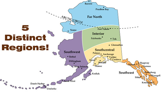
Alaska has several distinct geography and climate zones,
and it's important for educator candidates to understand
them, and how they differ.
Because Alaska stretches 1100 miles north to south, and
over 2000 miles east to west, there are significant
differences in both the amount of daylight in winter and
summer, and the temperature ranges are far wider than most
realize. And, as climate determines vegetation, there
are some very real distinctions in the whole visual
landscape appeal each area offers. This also impacts
what recreational opportunities are available.
Regardless, all areas of Alaska are strikingly beautiful in
their own way. This page only gives a brief synopsis
of the regions below, but you can learn much more about
Alaska's weather, geography and climate zones on the Researching
Locations page.
The State of Alaska has an excellent page for kids describing
each
of
the
areas in detail. This map links to that
page, which we recommend as a resource. For each
region we have below a:
Note that there are slightly different definitions of the boundaries of the regions, depending on who you ask, or the map you are using. In fact, some school districts may span parts of two regions. For our purposes on the ATP website, we will try to use the boundaries and definitions the official State of Alaska uses.
SOUTHCENTRAL
Southcentral is
home of Alaska's largest - some would say only - major
city: Anchorage, population 291,131 in 2021, or roughly
40% of Alaska's total population. The Matanuska-Susitna Valley (Mat Su
area) is commuting distance from Anchorage. The
Kenai Peninsula Borough is connected by road and rail to
the south.
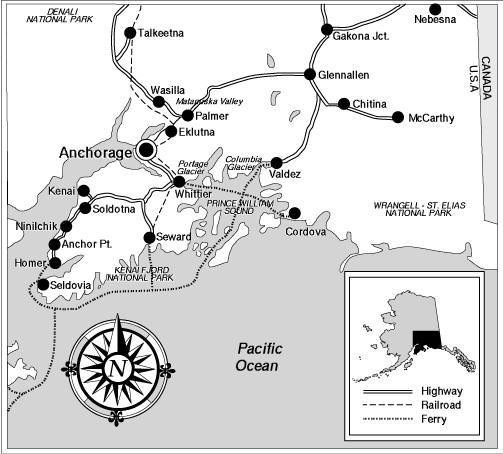
Southcentral has
the only major road "highway" sections, many airports of
all sizes, the Alaska State Ferry system, and the Alaska
Railroad. You can really get around, but finding a
position as a new-to-Alaska teacher can be difficult. Many
teachers gain experience in the Bush, and after some
years, many relocate to Southcentral communities
Southcentral Outdoor Recreation & Natural Resources
It is also really a gorgeous area, mountains to the sea, forests, glaciers, fjords, roadside lakes, clamming, salmon and halibut fishing, beaches, hiking and climbing in all seasons. Fall is spectacular, and results in "termination dust" (snow) on the peaks in September or so. Then, after the first snows at sea level, skiing (downhill and cross country), snowmobiling and ice skating are popular activities all winter. The Kenai Peninsula, a scenic and fly-fishing paradise, and Kenai Fjords National Park are to the southwest by road. Prince William Sound is a drive away, as are the coastal fishing communities of Seward and Homer. Wrangell-St. Elias National Park, to the west, contains nine of the 16 highest peaks in the United States.
Be sure to check
out the Alaska State Parks & Recreation information
for:
Click the image
below to view a new window with very detailed information
about outdoor recreational opportunities in the parks
& wilderness areas in the Southcentral region from the
Alaska Public Lands Center. Note that the Alaska Public Lands Center's website is temporarily down, so this link has the latest Internet Archive capture of the page. Be patient, as it will take several seconds to load the content.
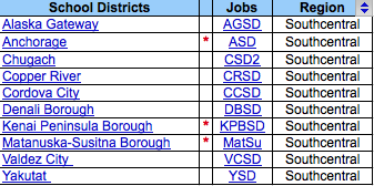
School Districts Located in Southcentral
Alaska
Several of the ten school districts in this area are among
the most sought after by teacher candidates. This is at
least partly because everything - shopping, recreation,
medical care and infrastructure - is all more easily
accessible than anywhere else in Alaska. Most are on the
road and/or Alaska State Ferry system. The list here links
to our Alaska
School
Districts
page for links to each organization's website and
jobs list.
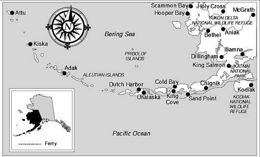
Southwest Outdoor Recreation & Natural Resources
Many consider
the Alaska Peninsula and Aleutian Islands as having some
of the true gems of Alaska's jewel box of natural
resources. Southwest has both dramatic areas, with
too many volcanoes to count, the amazing Katmai National
Park, and the Wood-Tikchik and Iliamna lakes systems for
camping, fishing, hunting and wildlife viewing. And,
more subtle beauty in coastal tundra and "pothole" ponds
among meandering rivers in the Yukon-Kuskokwim Delta
marine mammals galore. There is also world class
fishing, kayak and animal viewing in the Kodiak, Afognak
and Shuyak islands area. Finally, there are the
rugged and remote islands of Aleutian and Pribilof Islands
dividing the Pacific and Bering Seas with hillsides of
alpine tundra, thousand foot waterfalls, cliffs and black
sand beaches, sea stacks and puffin colonies.
Be sure to check
out the Alaska State Parks & Recreation areas for:
Click the image below to view a new window with very detailed information about outdoor recreational opportunities in the parks & wilderness areas in the Southwest region from the Alaska Public Lands Center. Note that the Alaska Public Lands Center's website is temporarily down, so this link has the latest Internet Archive capture of the page. Be patient, as it will take several seconds to load the content.
School Districts Located in Southwest Alaska
There are twelve
school districts, and one regional health care
organization that hire educators are listed here. Most of
their district offices are located in regional hubs with
grocery stores, and regional or sub-regional health
clinics. Kodiak is the largest population and in terms of
infrastructure and regular transportation There are
dramatic differences among and between these communities,
even though they are all in the same "region". The list
here links to our Alaska
School
Districts
page for links to each organization's website and
jobs list.
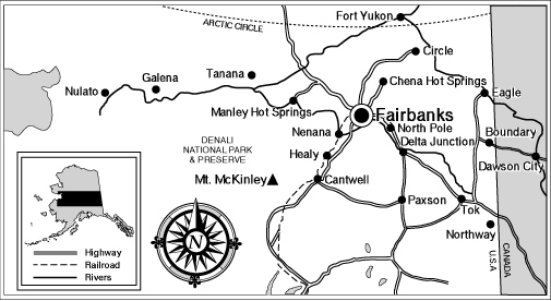
The Interior has
Alaska's second largest community, the small-ish city of
Fairbanks (population 32,703 in 2021), and a variety of
other school districts located both in the Bush, and on
the various spurs of the Road System. Fairbanks also
has the main campus of the University of Alaska, which is
where ATP's office is located, and a significant military
base community.
Interior Outdoor Recreation & Natural Resources
This region has
some of the best views of the Northern Lights (Aurora
Borealis) in the world, cold winters, hot springs, days
that seem to never end in the summer, short days in the
winter. Some of the most northerly communities are just
above or near the Arctic Circle, while others are not all
that far to drive from Anchorage. There is a very
good road between Anchorage and Fairbanks, and spur roads
that come off of that highway that support smaller
communities, and cross over into Canada.
The major rivers
in this area - primarily the mighty Yukon and the Tanana
- are both the subsistence lifeline for many
communities, and serve as a transportation system. Ice
roads exist in several areas when winter conditions are
suitable. Most travel is by small airplane, snowmachine
(snowmobile), or boat.
Denali, the
highest mountain in all of North America, is surrounded by
Denali National Park and Preserve - perhaps America's best
managed, and most spectacular parks. As part of the
extended Alaska Range, this area boasts spectacular
mountain vistas, berry-laden tundra, and an abundance of
wildlife including caribou, moose, Dall sheep, and grizzly
bear. Hunting, trapping, ice fishing, dogsledding, and
cross country skiing are all very popular winter pursuits.
Fairbanks even has an active running
community that holds organized events all year, such
as the Chilly
Buns
Mid-Winter
Run.
Be sure to check
out the 16 Alaska State Parks & Recreation areas for:
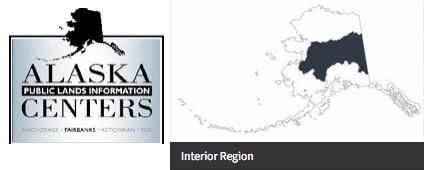
Click the image
below to view a new window with very detailed information
about outdoor recreational opportunities in the parks
& wilderness areas in the Interior region from the
Alaska Public Lands Center. Note that the Alaska Public Lands Center's website is temporarily down, so this link has the latest Internet Archive capture of the page. Be patient, as it will take several seconds to load the content.
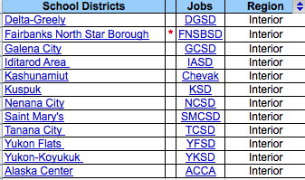
School Districts Located in Interior Alaska
School districts
here are diverse, with a Fairbanks being a large, city
setting, and several others being fly-in only Bush
districts. Finally, some are fairly remote by Lower 48
standards, but still on the Road System, so have
self-driving connections to the amenities found in the
urban areas of Anchorage and Fairbanks. The Bush villages
are mostly Athabascan Alaska Native communities, and subsistence lifestyles are
still common.
The are eleven school districts, and one
organization in this region. Fairbanks and the Alaska
Center for Children are located on the road system in an
urban setting. Nenana is a town on the road between
Fairbanks and Denali National Park. There is a new road to
within six miles of Tanana, and an ice road
connects that community seasonally. The others are all
more remote and/or Bush locations. YKSD has a district
office in Fairbanks, but serves villages that are fly-in
only. The list image links to our Alaska
School
Districts
page for links to each organization's website and
jobs list.
FAR NORTH
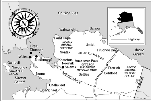
This area is all
either near or above the Arctic Circle. It has huge
wilderness areas, vast herds of migratory caribou, musk
oxen, mountain ranges and huge swaths of tundra
wildflowers and berries in season. The Northern Lights
are, of course, prominent during the dark months, as is
the sea ice of the frozen Bering and Chukchi Seas.
These communities are all effectively fly-in only,
although there is one limited access "haul road" that is
used to connect the oil fields of the North Slope with the
road system.
Far North Outdoor Recreation & Natural Resources
Traditional
subsistence lifestyles prevail in some of the most
traditional Inupiaq and Siberian Yup'ik Eskimo villages
left in North America. Migratory birds and marine
mammals are both appreciated and harvested throughout the
coastal areas. Truly some of America's
best
wilderness
is found in this area, with Gates of the Arctic National
Park & Preserve, the adjacent Noatak National Preserve
and Kobuk Valley National Park. The 180,000 member
Porcupine Caribou Herd migrates through the Arctic
National Wildlife Refuge.
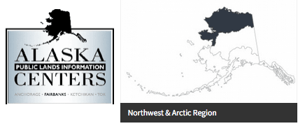
Click the image below to view a new window with very detailed information about outdoor recreational opportunities in the parks & wilderness areas in the Far North region from the Alaska Public Lands Center. Note that the Alaska Public Lands Center's website is temporarily down, so this link has the latest Internet Archive capture of the page. Be patient, as it will take several seconds to load the content.
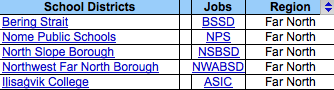
School Districts Located in the Far North
The school districts in this region include three that are larger than many entire states - Bering Strait, Northwest Arctic and North Slope - and one that is a regional hub city with a rich history and regional road system - Nome. Some consider BSSD and Nome as part of "Western" Alaska or "Southwestern", but the state website puts it in the Far North category, as it has villages along the coast and islands of the Bering and Chukchi Seas. One of BSSD's schools is 1.5 miles from the International Dateline and border with Russia, and you can see the Russian coast from three others. Really. Ilisagvik Community College is located in Utqiagvik (formerly Barrow), which is also the location of the North Slope Borough School District, and has a local road system.
SOUTHEAST
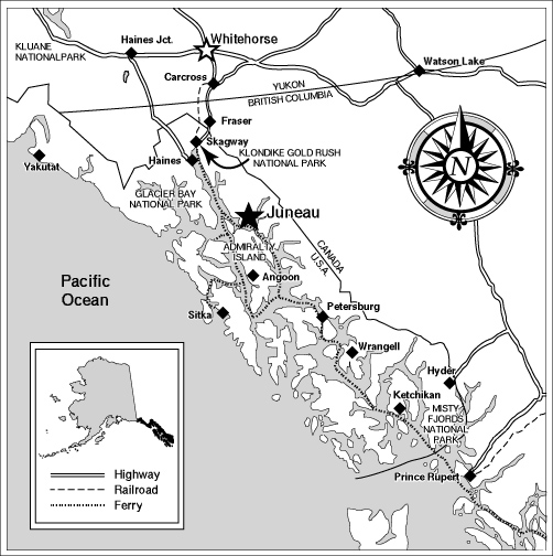
Southeast Alaska
has many islands, bays carved by calving glaciers, is
carpeted with rain forests of hemlock and spruce,
Alaska's Inside Passage is where cruise ships seasonally
glide past snow capped mountains, deep fjords, and
islands. The climate is a wet, mild, maritime climate, and
is rich with bald eagles, sea lions, porpoises, and
whales.
The capital city of Juneau was founded during the Gold Rush, and Sitka was originally the capital of Russian America, but is now home to both a school district, and the state residential boarding high school. Petersburg is rich in Norwegian heritage. The spirit of the Gold Rush is still visible in Skagway.
Southeast Outdoor Recreation & Natural Resources
Glacier Bay National Park has
16 active tidewater glaciers. Misty Fjords National
Monument near Ketchikan has 3,000 foot cliffs rising
directly from the ocean, and Tongass National Forest - the
nation's largest - has nearly 17 million acres and many
federal and state operated recreational areas.
Be sure to check
out the Alaska State Parks & Recreation areas for:
Click the image below to view a new window with very detailed information about outdoor recreational opportunities in the parks & wilderness areas in the Southeast region from the Alaska Public Lands Center. Note that the Alaska Public Lands Center's website is temporarily down, so this link has the latest Internet Archive capture of the page. Be patient, as it will take several seconds to load the content.
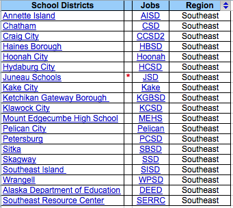
School Districts Located in Southeast Alaska
There are sixteen school
districts, a statewide boarding school, and two other
education organizations in Southeast Alaska. The largest
district is Alaska's captial city of Juneau, but there is
a mix of other types of settings, including small towns,
Alaska Native villages and logging camp schools.
The list here links to our Alaska
School Districts page for links to each
organization's website and jobs list.
Hopefully, you have learned a bit about the regions of Alaska here. But, you may want bookmark this page to refer to as you get more involved in your Alaska job search. The next steps for most candidates would be: